CARTOGRAPHY AND GEOLOGY
VARIOUS MAPS OF EACH LAKE IN THE THREE LAKES CHAIN ARE AVAILABLE
A BIRD’S EYE VIEW
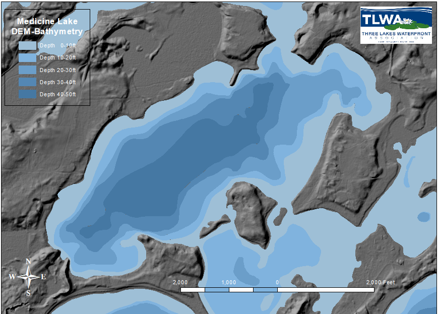
A variety of maps are available for each lake in the Three Lakes Chain. They include aerial photography, Digital Elevation (DEM) topography and bathymetry (water depth), membership status and from Onterra, Assessment of Shoreline Condition, Woody Habitat and Aquatic Plant Communities. The map to the right is an example of a Digital Elevation Model (DEM) of the Medicine Lake and Laurel Lake area. Note a topography of lowlands surrounded by raised platforms or mesas shown in gray and the water depths shown in shades of blue. The Three Lakes Chain dropdown menu on the header lists your favorite lakes for viewing and downloading these maps. Learn more about how they are constructed in “The Power of Maps” full article.


ONTERRA MAPS
The Lake Management Plan research created a three maps for each lake on the chain. These maps include a Shoreline Condition Assessment where development has been mapped ranging from undeveloped to urbanized in five gradations. Development degree has a direct bearing on a lake’s ability to maintain its natural flora, fauna and water quality. A second set of maps shows Woody Habitat or forest cover along the shoreline. The third set, an example shown at left for Medicine Lake, depicts small and large aquatic plant communities and dominant species present. The Onterra maps are included on each Lake Page accessible from the Three Lakes Chain dropdown menu.

Geology
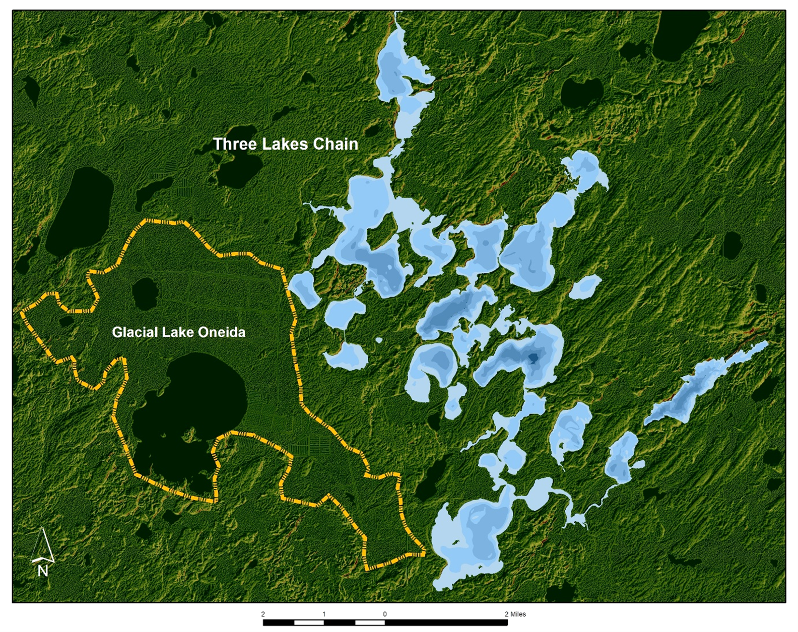
The beautiful landscape of the Three Lakes area has been largely sculpted by geological forces since glaciers retreated about 8,000 years ago. Indeed, our geological history spans a period of over 3.5 billion years and the shape and orientation of our lakes is a direct result of the underlying bedrock. A map of the Three Lakes Chain of Lakes, Oneida County, Wisconsin is shown at right. The topographic surface from digital elevation is shown as the base map in shades of green. This surface has a distinct grain running diagonally from the upper right to lower left (NE to SW) which was the direction of ice flow during Wisconsin Glaciation. An ancestral lake, Glacial Lake Oneida once covered an area including Thunder Lake and surrounding marshland. The shades of blue represent water depths (bathymetry) that provide a sense of underwater topography. For more information see “The Geology of the Three Lakes Chain” excerpted below or the full article.

NOW THAT’S A BIG ROCK
GLACIAL ERRATICS IN THE THREE LAKES REGION
EXTRA. EXTRA. READ ALL ABOUT IT! The headline of the local Gazette 10,000 years ago might have proclaimed: “Three Lakes Invaded by Giant Rocks”. No doubt, a “blast from the past.” Indeed, our area lay under thousands of feet of glacial ice back then and when it all melted away, the countryside was strewn with erratic rocks of all compositions, shapes and sizes. Disorder in the house!

Larry Zibell stands guard at the base of this sizeable remnant of our glacial history resting on private land near Stormy Lake, WI.
A glacial erratic is a rock that was picked up, carried away, and deposited elsewhere by a glacier. Indeed, the name is derived from the Latin “errare”, to wander. It can be noticeably peculiar like a lone boulder sitting in an otherwise soil covered field or poking its head above water level in a lake. Some have attained namesake status for local lakes (Rock, Little Rock, Stone, Little Stone, Big Stone, Lone Stone, Stepping Stone etc.) and they even adorn top-notch destination resorts (Big Stone Golf Course). It is no surprise that the “Rocks for Fun Pasty Shop” emerged from extensive boulder fields along HWY 45 just north of Tigerton, WI. Elsewhere, one may have spotted cultivated fields lined with rock walls and thought, “How quaint“ only to later realize that “the boulder is the bane to the plow” and then upon reflection, how they toiled to clear these once untillable fields. “Erratics” full article.

GEOLOGICAL MYSTERIES OF THE UNDERGROUND REVEALED
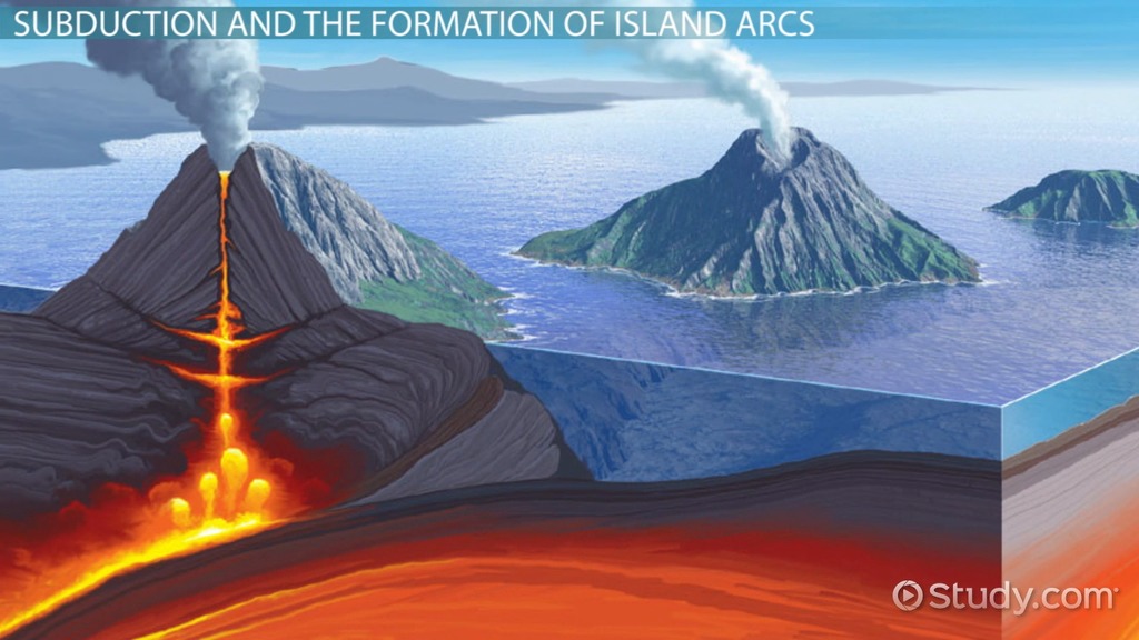
Three and a half billion years ago in the Precambrian Era, mountain-building forces deformed and recrystallized rock at high pressures and temperatures to create a basement of swirly layered gneiss (‘nice’). From 1860 to 1500 million years ago, volcanism is rampant, lava and sediment deposit in deep ocean basins and granite plutons invade the countryside as depicted in the illustration above. Since then, northeastern Wisconsin has been a remarkably stable highland compared to most of North America, which was inundated by shallow seas and covered by thousands of feet of limestone. Local geological history over the last few million years is written by climate change and continental glaciation.
Climate fluctuated multiple times during the past 2.6 million years. This time frame, known as the Quaternary Period, is considered an “ice age” due to the continuous presence of at least one ice sheet (Antarctica). In the past 700,000 years, climate is seen to oscillate in 100,000-year cycles consisting of long periods of cooling with the formation of glaciers and shorter periods of warmer temperatures and melting. The last cooling cycle in North America is known as the Wisconsin Glaciation.
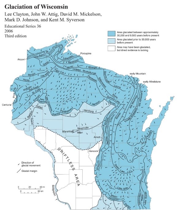
At the onset of Wisconsin Glaciation, the Laurentide Ice Sheet forms and begins to spread across the mid-continent of North America. Laurentide advances into Wisconsin 31,500 years ago and makes its furthest advance to the south around 18,000 years ago. At your front door, ice is 5000 feet thick and is moving at a rate of an inch or two a day. It has the erosive power to gouge out lake-sized depressions from softer rock and ride over and polish smooth more resistive rock like granite. During this glacial cycle, the global temperature is estimated to have been only eleven degrees cooler than the 20th Century average.
When global temperatures warm, glaciers in our region begin retreating. Hard to imagine this vast sheet of ice, thousands of feet thick, let alone the quantities of water generated during melting and runoff. Starting as a trickle, water-speeds progress to sheet flow and rivulets to whitewater rapids that continually influence the size-fraction of sediment transported.
At 10,000 years, this retreat stalls long enough for the glaciers to propel sufficient water and sediment to create our current landscape. This includes ancestral Glacial Lake Oneida, a 15 square mile lake that coincides with the present-day extent of Thunder Lake and the surrounding marshes and cranberry bogs (Figure above). When the Laurentide ice sheet finally leaves the region, a thickness of up to 200 feet of sediment is left behind to fill in and level out a more rugged ancestral terrain.
These sediments consist of a braided system of interbedded silt, sand, gravel and boulders, some of which are as big as a house. The glacial units are stratified gravelly sands deposited from streams and outwash plains, ice-walled rivers and deltas and with blocks of ice that after melting, form collapse structures characterized by a hummocky, uneven forest floor with local sinkholes. A conspicuous field of low, elongated ridges (drumlins) on the eastern flank of the Chain lie parallel to the direction of ice flow and form by glacial ice gliding over older bodies of till and carving out grooves to produce a fluted landscape.
Once this climatic ruckus quiets down, vegetation sprouts and soil develops. The soil profile reveals a northern arboreal forest climate with periodic changes to a humid rainforest which produces a thick organic-rich topsoil. Soil compositions are inherited from the underlying glacial sediment and include light-sandy and heavy-sandy loam (equal parts sand and silt with about 20% clay) interspersed with areas of muck and peat.
