Maximum Depth
acres
native plant species
Volume (acre feet)
THE THREE LAKES CHAIN PHYSIOGRAPHY
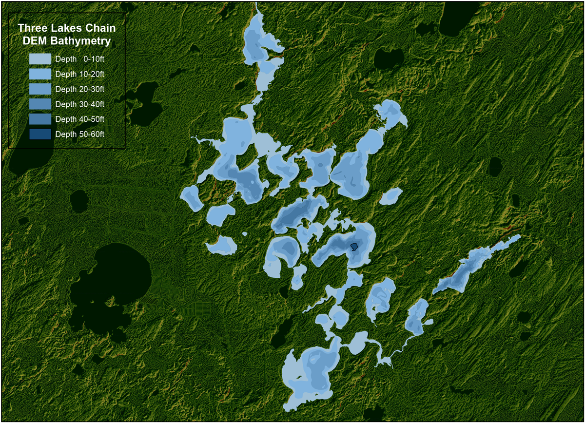
The Three Lakes Chain resides in the “Northern Lakes and Forests” ecoregion in Wisconsin in north-eastern Oneida County and consists of 21 lakes and 2 waterways. The chain drains north as the Eagle River over the Burnt Rollways Dam into the lower Eagle River Chain of Lakes. The date of the original dam construction is circa 1893 when the Nine Mile Creek Improvement Company was authorized to build. The Wisconsin Valley Improvement Company (WVIC) controls flowage at the dam and has a federal license specifying water levels be kept between 1,625.71 and 1,622.96 ft.

"A RIVER RUNS THROUGH IT"
The Three Lakes Chain is part of the Eagle River system and contributes 71,000 Acre-feet of water annually making its way to the Wisconsin River and on to the Gulf of Mexico. What is not apparent is the dynamic nature of these serene lakes that could be considered sleeping giants.
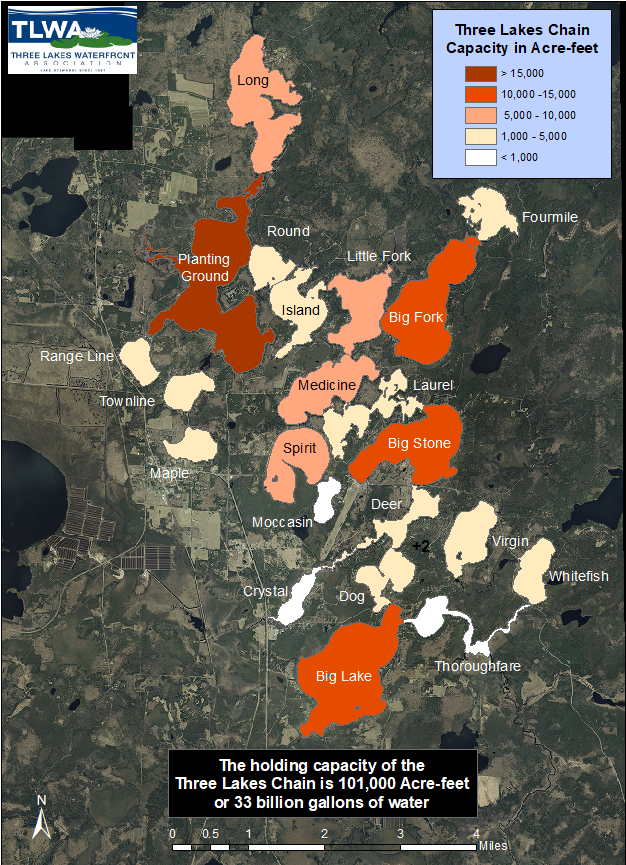
How much water is in your lake? The Three Lakes Chain, aka the Burnt Rollways Reservoir holds over 100,000 Acre-feet of water or about 33 billion gallons. The table lists the individual lakes in the chain arranged by capacity. Planting Ground is clearly the reigning champion followed closely by the triumvirate of the aptly named Big Stone, Big Fork and Big lakes. These four basins contain half of the entire water budget of the reservoir.
| Lake | Surface Acres | Mean Depth | Capacity Acre-Feet | Volume % | Refresh Rate (times/year) | Total Flow/year (Acre-feet) | Residence Time (days) |
| Planting Ground | 1045 | 15 | 15675 | 15 | 4.3 | 67403 | 88 |
| Big Stone | 609 | 20 | 12180 | 12 | 4 | 48720 | 91 |
| Big Fork | 670 | 17 | 11390 | 11 | 0.8 | 9112 | 453 |
| Big | 872 | 13 | 11336 | 11 | 3.6 | 40810 | 102 |
| Medicine | 397 | 22 | 8734 | 9 | 5.8 | 50657 | 62 |
| Long | 613 | 12 | 7356 | 7 | 9.7 | 71353 | 37 |
| Little Fork | 343 | 16 | 5488 | 5 | 10.9 | 59819 | 33 |
| Spirit | 355 | 14 | 4970 | 5 | 0.2 | 994 | 1544 |
| Virgin | 264 | 13 | 3432 | 3 | 2.3 | 7894 | 161 |
| Island | 304 | 11 | 3344 | 3 | 18.6 | 62198 | 18 |
| Whitefish | 199 | 16 | 3184 | 3 | 3.2 | 10189 | 113 |
| Fourmile | 210 | 11 | 2310 | 2 | 3.5 | 8085 | 106 |
| Laurel | 254 | 7 | 1778 | 2 | 27.1 | 48184 | 15 |
| Deer | 188 | 9 | 1692 | 2 | 28.1 | 47545 | 15 |
| Range Line | 128 | 13 | 1664 | 2 | 0.6 | 998 | 606 |
| Dog | 204 | 8 | 1632 | 2 | 24.7 | 40310 | 15 |
| Townline | 145 | 11 | 1595 | 2 | 1.5 | 2393 | 245 |
| Round | 151 | 8 | 1208 | 1 | 49.3 | 59554 | 7 |
| Maple | 139 | 8 | 1112 | 1 | 0.5 | 556 | 748 |
| Moccasin | 91 | 8 | 728 | 1 | 0.4 | 291 | 843 |
| Crystal | 117 | 6 | 702 | 1 | 8.5 | 5967 | 44 |
| Total | 7298 | 101510 | |||||
| gallons/Acre foot | 325851 |

WATER CAPACITY OF THE CHAIN
All the lakes on the chain are classified as drainage lakes in that they have surface water inflow and/or outflow in the form of rivers or streams, some demonstrably more than others. Lake water capacities are color-coded from dark to light representing large to smaller volumes.
The darker colored lakes including Planting Ground and the triumvirate “Bigs” – Big Fork, Big Stone and Big Lake contain nearly half of the entire water budget in the Chain.
FLOWAGE RATES OF "THE HIDDEN RIVER" ON THE CHAIN
Since our water is constantly on the move, it is interesting to note the refresh rate or conversely, the residence time of water in our lakes. The Refresh rates from table above, show the number of times per year that the holding capacity of each lake is displaced by the inflow of water from upstream. For example, Laurel Lake (27 times) is refreshed every two weeks, Medicine (5.8) every two months and Spirit (0.2) once every five years. If you happen to live along the main channel, somewhere between 30 and 60 million gallons of water are cruising past your pier every day. It’s no wonder fish on the chain like to find a nice back bay to chill out.
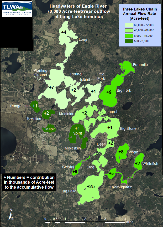
The overall flow of Eagle River begins in the lower right corner of the map in the headwaters near Whitefish and Virgin lakes and picks up steam at Big Lake turning northerly along the trail of light green colored lakes. The darkest colored lakes on the left side from northwest to southeast: Range Line through Moccasin as well as Big Fork Lake contribute to the overall budget but are not “main channel lakes.”
Teamwork amongst the lakes provides 71K Acre-feet of water pouring out of the Burnt Rollways dam on a yearly basis. This impressive “ hidden river” flow emanating in the ‘headwaters’ wends its way along The Thoroughfare to collectively decant 15K acre-feet or more into the northeast end of Big Lake. Big Lake and its watershed adds a gushy 25K acre-feet to this flow and together 40K acre-feet are quietly rumbling down drainage into Dog Lake. Reserves from Deer Lake and Crystal Lake bring the outflow to nearly 50K acre-feet which then takes a breather and maintains equilibrium from Big Stone through Laurel and Medicine. At Little Fork, the river receives a 9K acre-feet influx from Big Fork which boosts it to 60K acre-feet as it continues through Island and Round into Planting Ground. The final contributions from Planting Ground and Long lakes result in 71K acre feet flowing out towards Burnt Rollways Dam and eventually into the Wisconsin River system.


